Pictures:
|
|
|
Enters Wake County at exit 283/I-540.
Leaves Wake County at mm 310, 5 miles south of Garner.
|
Major
Intersections:
|
Wade Ave. Extension, exit 289.
NC 54, exit 290.
US 1, US 64 and I-440, exit 293.
M-I-440 and US 64 from exit 293 to exit 301.
US 70/US 401/NC 50, exit 298.
I-440 and US 64 split off at exit 301.
US 70 (again), exit 306. |
History:
|
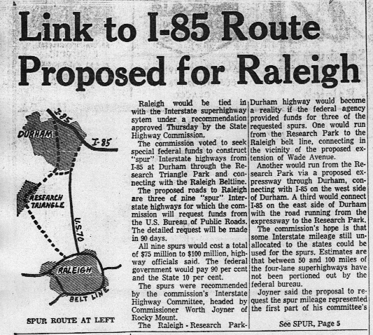
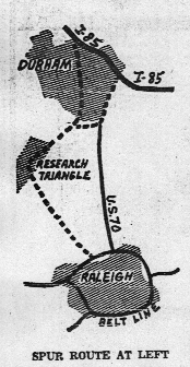 The predecessor to I-40 was a spur route proposed to run from I-85 in Durham to meet the southern half of the Beltline. Proposed around 1963, just as the original part of the Beltline was in the completion stages, the plan was designed in response to government concerns that Raleigh was one of three state capitals (Carson City, NV and Dover, DE being the others) which had no connection with the Interstate system. At the time, I-40 ended in Greensboro and the spur was proposed to be a 3di from I-85. Most of this route was built as the Durham Freeway (between I-85 and RTP) and the "NC 54 Freeway" between RTP and the Beltline. This later became part of I-40. The picture to the left is a crude drawing appearing in a News and Observer article announcing the construction; the entire first page of the article, including this drawing, is available here. The dotted lines around the east side of Durham are the still as-yet-unconstructed "East End Connector"; there are ghost gradings on the Durham Freeway indicating where this road would go. The predecessor to I-40 was a spur route proposed to run from I-85 in Durham to meet the southern half of the Beltline. Proposed around 1963, just as the original part of the Beltline was in the completion stages, the plan was designed in response to government concerns that Raleigh was one of three state capitals (Carson City, NV and Dover, DE being the others) which had no connection with the Interstate system. At the time, I-40 ended in Greensboro and the spur was proposed to be a 3di from I-85. Most of this route was built as the Durham Freeway (between I-85 and RTP) and the "NC 54 Freeway" between RTP and the Beltline. This later became part of I-40. The picture to the left is a crude drawing appearing in a News and Observer article announcing the construction; the entire first page of the article, including this drawing, is available here. The dotted lines around the east side of Durham are the still as-yet-unconstructed "East End Connector"; there are ghost gradings on the Durham Freeway indicating where this road would go.
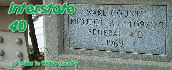
The 3dis from I-85 never came to pass as originally planned; I-40 and the (at the time) unnumbered Durham Freeway took their places. The western section of I-40, including the Wade Ave. Extension (which was signed TO I-40 - see "comments", below), was completed around 1970 as a 4-lane freeway. The bridge marker at the top of the page is an original from I-40's initial construction.
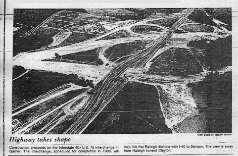
In 1985, the southern section of 40 around Raleigh, exits 289-301, was completed. This section was proposed for over 20 years, but neighborhood protests and difficulty in right-of-way acquisition delayed the road's construction. Along this route, I-40 was co-signed with US 64, US 70, US 401, and NC 50 (from exit 298 on), creating "Multiplex Hell" on the Beltline. It was originally 4 lanes, like the western section, but the 2 parts were quickly widened to 6 lanes (by 1987, both sections were at least 6 lanes). The section between I-440 and the second US 70, miles 301-306, was completed in 1989, and the final leg (which stretched to NC 210 in Johnston County) was finished in 1990. 40 was finished to the coast in 1991.
Today, I-40 carries at least six lanes through the entire county (and eight between I-540 and Wade Ave.), with two exceptions: east of exit 306 (US 70), and between exits 289 (Wade Ave.) and 293 (I-440/US 1/64). The latter section is funded for widening in the 2006 TIP, with construction to begin in 2009. |
Attractions:
|
RDU Airport is right off of 40, at exits 284 and 285. The RBC Center, home of the Carolina Hurricanes and NC State basketball, along with NCSU's Carter-Finley Stadium, is along the side of Wade Ave. (exit 289). Last, but not least, the State Farmers' Market is at exit 297. |
Comments:
|
I-40 is by far the most famous and most infamous road in Wake County. The westernmost part of 40 has nearly no median, and just a small barrier separating opposing traffic; this is a testament to how badly 40 needed a widening in the mid '90s that every conceivable expense was spared to simply get the road widened.
The location of Research Triangle Park in relation to Raleigh leads to an anomaly in commuting patterns: the heaviest traffic on I-40 heads away from Raleigh in the mornings, and toward it in the afternoons. The worst traffic is by far in the afternoons; backups often begin at the Durham Freeway in RTP and don't let up until US 1 in Cary, 14 miles later. The bridge over I-40 between Harrison Ave. and Aviation Pkwy. has baffled commuters for years. The bridge carries a road named Old Reedy Creek Rd., which at one point (before I-40 was built) was a through route through what is now Umstead State Park to the extant Reedy Creek Rd. in west Raleigh. The route was severed in the mid '60s, around the time I-40 was built, which left DOT with a problem: there was one solitary house on the north side of I-40 that needed access to the outside world -- so the department built a bridge that amounted to a driveway to the house. The land to the north of 40 is now owned by the Raleigh-Durham Airport Authority, and the house has long since been abandoned, but the bridge remains as a part of a popular biking trail into Umstead Park. To see a car driving across the bridge, though, requires some incredible luck; probably no more than five cars a day cross the bridge.
The Wade Ave. interchange (exit 289) wasn't built at all until the southern part of I-40 south of downtown Raleigh was completed in 1985. Westbound Wade Ave. uses the same alignment as it did when no interchange existed, and the old alignment of eastbound Wade can be seen through the trees along westbound. Look to your left past Edwards Mill Rd. and you'll see some newer and smaller trees among the larger ones -- that's the old alignment of eastbound Wade. (For the record, Wade Ave. was never signed as I-40 per se; rather, it was signed TO I-40 due to an interstate-incompatible driveway into Carter-Finley Stadium from the freeway itself. The designation began either at Harrison Ave. or at the location of today's Wade interchange; I'm not sure exactly where.)
I-40 from Raleigh east travels very desolate territory; the biggest city along 40 between Raleigh and Wilmington is Wallace in Duplin County, population 3,344. |