Click Here for the I-540 Exit List | Jump to NC 540
|
|
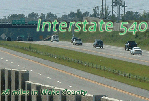
Begins at I-40 exit 283. (This is technically in Durham County, but only by about 100 feet.)
|
Major
|
I-40 (exit 1), US 70 (exits 4A-B), US 1 (exit 16), US 401 (exit 18), and US 64 (exit 26).There are three SPUIs along 540 -- the first, at Six Forks Rd (exit 11) opened in June 2001; the second, at Triangle Town Blvd (exit 17), opened August 12, 2002 (but is only 3/4 open since Triangle Town ends at 540); and a third, at US 401, opened with the newest extension in January 2007. |
History: |
I-540 has only been around since 1997, but its history predates that opening by almost thirty years. Planning for what became I-540 began in the early 1970s, when the Beltline was still less than ten years old and Lynn Road was the edge of North Raleigh civilization.The dedication of Research Triangle Park in 1959, followed by the opening of IBM in the park in 1962, led to multiple new subdivisions in North Raleigh, including North Ridge, Quail Hollow and Brentwood. The only freeway in Raleigh was the Beltline at this point, and the only way into RTP was two-lane NC 54, as I-40 (known at the time as the NC 54 Freeway) was still on the drawing books and wouldn't be completed until around 1970.Soon after I-40 was first completed, the need for an east-west freeway through North Raleigh became apparent. All traffic headed to RTP was forced to take north-south roads down to the Beltline, then get on 40 to head out to RTP. The presence of Umstead State Park and the RDU Airport prevented a direct connection from north Raleigh to I-40 near RTP, so any connection would need to go to one side or the other of the obstructions. A southern route to the southeast of Umstead Park would be much more contentious because of the addition of so many new neighborhoods in north Raleigh, although it eventually was added to the map as the now-cancelled Duraleigh Connector. The northern route, which eventually became I-540, would be routed through land that was years away from development.The Northern Wake Expressway, the original working name for the freeway, was first put on planning maps in 1976, and routed along the edge of the Falls Lake watershed. By 1985, neighborhoods had appeared in far north Raleigh in anticipation of the new freeway; the advance placement of the road's route on maps allowed developers to plan their neighborhoods around the route of the freeway. As a result, very few buildings were condemned to build the road, and construction crews simply had to clear the trees out of the right-of-way.By the mid-'80s, growth in western Wake County led NCDOT to expand the planned route of the Expressway to be a full loop around Raleigh, roughly at a 15-mile radius to downtown. However, the preliminary work that had been done in north Raleigh was not impacted by the expansion, as the remainder of the road was simply mapped out as the first segment had been with no additional money spent on right-of-way or construction.While the Beltline was designated I-440 in 1991, the Northern Wake Expressway (commonly shortened to the Outer Loop, which is still a name used today though the Northern Wake Expressway name is only used on maps) was unnumbered until 1996, when it was announced that the Expressway would be named I-540 -- but only until the freeway hooked up to I-40 on both ends, at which point it would be renamed I-640. (See below for what happened to this idea.)The first section of the freeway, connecting I-40 to Glenwood Avenue to the northwest of the airport, opened on January 21, 1997 and immediately changed commuting patterns all over north Raleigh. Instead of being forced onto the Beltline and I-40 to get to RTP, commuters now headed west to Glenwood Avenue, then onto I-540 which emptied onto I-40 at the eastern edge of RTP. Since Glenwood (US 70) was the only access to the freeway from the east for nearly three years, it became severely choked with traffic to the point that RTP commuters who lived closer to the Beltline were better off taking the old route to work. The congestion at 540's eastern end, which moved further east every few years, was always terrible no matter what cross street the freeway ended at; it wasn't until the freeway was extended to Capital Boulevard in 2002 that delays were uncommon at the eastern end of 540.A side impact of the completion of 540's first segment benefitted the RDU Airport, as Aviation Parkway was relocated to cross 540 at exit 2 rather than parallel the freeway between the airport entrance and Glenwood Avenue. The eastern stretch of Aviation Parkway was renamed as an extension of Lumley Road, but a significant stretch was turned over to the airport authority's control as the location of a future runway. As a quick look at a satellite image will attest, the road has not been removed yet, although only airport service vehicles use it now.540 was extended east in shifts, as seen below:
When 540 was first opened between I-40 and Glenwood Avenue, it was signed as a north-south road. Then NCDOT got their hands on a map and, realizing that the vast majority of the freeway would run east and west through north Raleigh, they redesignated it as an east-west road, which it is signed consistently as. 540 does not have an inner/outer component, unlike I-440 and Charlotte's I-485; however, a precedent being set on new sections of I-485 will almost certainly be implemented on 540 at some point, where the freeway is signed as both inner/outer and with traditional cardinal directions.Whew, we're done. |
Comments: |
In a reversal of its original plan, NCDOT announced in 2002 that the road will remain 540 even after it hooked back up to I-40. It's not unheard of for odd 3-digit interstates to connect to other interstates on both ends -- I-780 and 980 in California, and I-390 and 590 in New York state all connect at both ends -- but it will be an anomaly nonetheless. (540 would be the first one to connect to the same interstate at both ends, though.)"Ghost ramps" exist on the south side of 540 between Glenwood Avenue and Leesville Road. I've heard conflicting reports on what these ramps will connect to; some sources have said it will be an extension of Alexander Dr., others say it is a remnant of the Northern Durham Expressway (Eno Drive) project.Up until the road made it to Capital Boulevard, everything east of Glenwood Avenue was signed as Future I-540, since all Interstates must end at a road that's a part of the National Highway System...none of the roads in between Glenwood and Capital qualified, so the unbelievably confusing Future signs ("What do you mean Future? It's open now!!") stayed for the better part of three years. Unlike the Beltline, 540 is referred to by its number quite often, even among Raleigh-area citizens. The Outer Loop is the second-in-command name, and the two are often used interchangeably. |

|
|
Begins at NC 55 south of RTP, exit 66. |
Major |
I-40 (exit 1), NC 54 (exit 69), NC 55 (exit 66) |
History: |
A true Only In North Carolina road. It looks like an Interstate, it was built with the intention of being an Interstate, and it was signed as an Interstate until about two weeks before it opened. So why in the heck is it NC 540?To make a very long story short, NC 540 is signed as such because it eventually will be tolled. The slightly longer version goes something like this:The NC General Assembly in 2005 approved the creation of the North Carolina Turnpike Authority, charged with studying and eventually building the state's first modern toll roads. One of the first projects considered by the authority was the originally-named Western Wake Expressway, which was intended to be I-540's western loop to the west of Cary and Apex. However, the authority originally sought authorization for tolls only on a loop to the west of NC 55, paralleling NC 55 to the west by a couple of miles around Apex and Cary. At this point, the first section of what's now NC 540, from I-40 to NC 55 in RTP, was already under construction as a westward extension of the existing I-540.Then, in early 2006, the authority reversed course and decided that they wanted the entire stretch of 540 to the west of I-40 to be a toll road. The stated reason for this change was that the authority also had jurisdiction over a southern extension of the Durham Freeway (NC 147), a toll road that would connect the existing southern end of NC 147 just past I-40 through the southern portion of RTP to the new stretch of 540 at the Davis Drive exit. (This extension is why the Davis Drive interchange is so overpowered; eventually it will be a junction of two freeways that will warrant the high-speed ramps in place.) The two separate toll roads would have been connected by a short free stretch between NC 55 and NC 147, but the authority wanted it to be one continuous tolled highway.Federal law, however, prohibits the spending of federal money on any tolled Interstate. Since 540 was originally planned to be a full Interstate and thus was built with the typical 90% federal funding for an Interstate, the Federal Highway Administration required NCDOT to no longer sign the new roadway as an Interstate. NCDOT, consequently, broke one of its own rules and gave the new freeway the same number as the existing portion across I-40, and NC 540 was born. (Remember, though, this is the same state that permits NC 73 to cross I-73 and US 74 to share pavement with I-74, so the rules seem to have very little impact lately on route numbering.)The only problem with this setup is that the I-540 shields were already posted on the roadway, and DOT crews had to scramble to replace all the Interstate shields with NC 540 shields two weeks before the road opened. Additionally, the exit numbers (which are based on a full loop of I-/NC 540 around Raleigh) were off by 19 miles when originally posted thanks to an error from the DOT GIS mapping unit, so at the same time the shields were being replaced, the exit numbers and mile markers on the new stretch were also being changed to reflect the correct mileage.Only in North Carolina. |
Comments: |
While the section between I-40 and NC 55 opened July 14, 2007 as a free highway, the Turnpike Authority plans to construct the loop to the west of NC 55 and open it by 2011, at which point the entire road to the west of I-40 will become a toll road. Without the tolls, DOT would not have the money to build the road until 2032 and open it as a free highway. |
