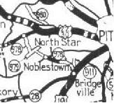
978 may not have always followed the same general alignment. 978 may have followed a more east-west route in the 1920's (Image 1). A Bridgeville to Santiago via Oakdale and Noblestown route appears to be the original alignment of PA 978. If so, it would have possibly left Bridgeville via Thoms Run Road, possibly hooking up with the current 978 through Oakdale to Noblestown Road and following modern PA 980 to the William Penn Highway (US 22).
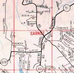
By 1940, PA 978 settled to its generally current routing, running north-south from PA 51 in Carnot to then PA 28 (until 1960, when changed to PA 50) in Treveskyn. The post-war opening of Greater Pittsburgh International Airport may have slightly altered the alignment of PA 978 to the west of the facility. However, it would not be until further growth of the airport would physical changes occur to northern routing of PA 978. Until 1975 or 76, PA 978 continued north beyond the Steubenville Pike (US 22/30) along Enlow Road, wound itself around the western and northwestern perimeter of Greater Pitt to Moon-Clinton Road. The 978 designation then turned left onto Beers School Road, now known as University Boulevard, and continued for another 1/4 mile to its northern terminus at PA 51 (Broadhead/Narrows Run Rd.) In the mid 60's, PA 60 was routed from the abrupt end of the Airport Parkway onto Beers School Road to PA 51 at Broadhead. (Image 2) PA 978 was more than likely truncated to terminate at PA 60/Beers School Road in front of Moon Stadium. (Image 3)
When PA 51 was moved from Broadhead Road to a route along the Ohio River in '75 or '76, PA 978 was truncated to end at the US 22/30 Freeway in Imperial. However, the later part of the decade saw a southern extension to PA 978. When the 4-lane PA 50 from I-79 to the Washington County Line was finished a few years later, PA 978 was extended along the old PA 50 westwards to the new highway near Cecil.
As stated above,
the growth and additions to Greater Pittsburgh International Airport has
altered the former alignments of PA 978. Many parts of the highway's
routing from the 30's to the mid 70's have been closed off or torn up.
Most of this occurred when the new Midfield Terminal was constructed and
opened in the early 90's. Tracing
the Past--PA 978 shows more.
Site Navigation, Sources & Links:
Page Created: August 10, 2002
Last Updated: September 28, 2003
(C) 2002-03 William Lawson
#1: 1929 Official (Bruce Harper)
#2: Champion
mid-60s (Bruce Harper)

#3: Former
Northern Terminus of PA 978
(Denny Pine)