The Route:
Pennsylvania State Route 51 runs
approximately 83 miles in a predominantly Northwest/Southeast direction
from US 40 Business in Uniontown to the Ohio State line just north of East
Palestine, Ohio. At the Ohio/PA border PA 51 becomes Ohio State Route 14
which runs Northwest to Cleveland, Ohio. So one can start in Uniontown
and end up in Cleveland by following the same road!!!
Over two thirds of PA 51 is 4 laned.
(Including the entire route from US 119 in Uniontown to the West End Circle
in Pittsburgh.) It is considered the main route from Pittsburgh to the
Mon Valley and Fayette County. And sadly, PA 51 is under construction frequently.
From US 119 to Elizabeth, it is very much similar to a rural at-grade four
lane divided expressway. It then turns suburban through the eastern
most reaches of the South Hills where it is the main access road to Century
III Mall. Upon crossing into the city limits of Pittsburgh, Route
51 becomes part of Saw Mill Run Blvd. where gridlock and aggravation prevails.
It then visits McKees Rocks and Coraopolis as the highway parallels the
shores of the Ohio River until crossing it near Beaver. The highway
returns to its rural four lane roots in western Beaver County into Ohio.
History:
Uniontown to Monongahela River
Crossing (Elizabeth):
For over 30 years, PA 51 snaked its
way through the Mon Valley towards Uniontown. Known mostly as 'Pittsburgh
Road,' route 51 was a tight two lane road with various hills and oxbows.
Although predominantly rural, PA 51 did go through the downtown's of Perryopolis
and Elizabeth. By the late 1940's, 51 moved out of central Perryopolis
on a 'bypass' about a mile to the west. Elizabeth was bypassed in
1951 with the completion of the Elizabeth Bridge. Previously 51,
entered Elizabeth via Market St., turned left onto Second Avenue and right
onto Plum St. before crossing the Monongahela into West Elizabeth.
During the 1950's PA 51 south of Elizabeth was straightened and widened
to four lanes. By 1953 (Image #1), 51 was widened from Elizabeth
to PA 48, and from the Westmoreland/Fayette County Line south to PA 711
(now PA 201). By 1957 most if not all of PA 51 was widened in Westmoreland
County, this includes the Rostraver Bypass that stretches from PA 201 south
to I-70. The 1960's saw the completion of the widening project to
Uniontown. It wasn't until 1996 that the last section of PA 51 south
of Pittsburgh was widened to four lanes. The stretch of 51 from Perryopolis
to Star Junction was widened from two lanes with center turn lane to four
lanes with center turn lane.
Monongahela River Crossing to
West End Circle:
The pre-1930 routing of Route 51
saw the road enter into West Elizabeth from the old Elizabeth Bridge, enter
Large via Scotia Hollow and McGrew Hollow Roads. 51 then was carried
above the Lewis Run Valley along Clairton Road through Jefferson Township
(now Jefferson Hills and Pleasant Hills Boroughs). It then similar
to the route south of the Monongahela, climbed numerous hills until descending
into the Saw Mill Run Valley and into the West End. In 1930, Saw
Mill Run Blvd. opened from Library Road to Banksville Road. The
new roadway eliminated many oxbows and provided a four lane roadway linking
the South Hills to the Liberty Tunnels. Later in the 30's, 51 was
moved into the Lewis Run Valley along a three lane road from Large to Lebanon
Church Road. This would include Allegheny County's first Cloverleaf
Interchange opening in 1939 at Lebanon Church Road.
Through the 1940's, 51 was straighten
and widened between the Cloverleaf and Library Road; and by 1951, two more
towns, West Elizabeth and the West End were bypassed. With a proposal
to connect Large and the new Elizabeth Bridge via tunnel failing, West
Elizabeth was bypassed by 51 ascending the Ridge and funneling into Large.
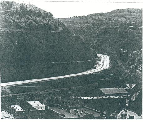
The West End Bypass (See Image #2), originally proposed by Robert
Moses, was built from the Banksville Traffic Circle to the West End Bridge.
The bypass eliminated the well known bottleneck in the area. Improvements
were made to the Lewis Run section, as it was widened from three lanes,
which had a very dangerous suicide passing lane, to four in the late 50s.
The Banksville Circle was eliminated with the construction of the Parkway
West in the late 50s.
The 60's & 70s saw a mix of expressway
and widening plans for Route 51, specifically along Saw Mill Run.
However, numerous local opposition groups blocked many proposals.
Since then, 51 has mainly seen numerous, if not to those who use it for
their commute, endless rehabilitations and minor upgrades. The most
significant was the Split-Diamond Interchange at the South Portal of the
Liberty Tubes. Also, Route 51 was widened and straighten yet again
in the Lewis Run Valley to accommodate an extra turning lane. This
work was done by the PA Turnpike Commission in conjunction with the PA
43 freeway.
West End Circle to Ohio River
Crossing (Beaver):
Most of the changes did not occur
until the 1960s. PA 51 was widened from Coraopolis to Broadhead Road
in the 1960's. Also, a new and four laned Broadhead Road was built
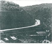
in the Monaca Area. In 1976, PA 51 was moved from Narrows Run and
Broadhead Roads onto the former alignment of PA 930 paralleling the Ohio
River. (See Image # 3)
Ohio River Crossing to Ohio
State Line:
Not much has changed to Route 51
in this area except for changes in the Rochester Area done in the 1960s.
Most of the work included new four lane highways and grade separated intersections.
Bannered Routes:
Alternate PA 51: Uniontown
Not sure on the years or the signing
of this route. However, it is shown on the Uniontown Inset of the
1953 Official. (See Image #4). It left PA 51 at Mt. Vernon
St. then turned East on US 40 (Fayette St.) and ended at US 40, US 119
and PA 51.
Truck PA 51 South: Elizabeth
Signed to bypass trucks from Elizabeth-McKeesport
Road heading to PA 51 South from Downtown Elizabeth. Begins at the
Second Ave. Ramp to PA 51 North, crosses over the bridge, and ends at the
U-turn ramp to PA 51 South. (See Image #5).
Finding the Old Road:
Has there own separate pages:
Finding Old PA 51
Uniontown to West End Circle
West End Circle
to Ohio Line ---Bruce Harper
|
#1: 1953 Official
showing Elizabeth to Uniontown
Routing.
#2: West End Bypass
Under Construction
(Clyde
Wright) Click to enlarge.
#3: 1940 Official.
PA 51 was moved onto the former
alignment of PA 930
in 1976.
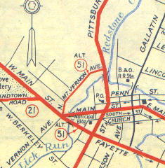
#4: 1953 Official.
Alternate PA 51
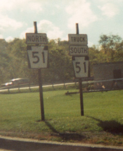
#5: Truck South
PA 51, Elizabeth. (William Lawson)
|