
Broken Dreams, Broken Promises
The History of the 'New 48'
From the 1950's to the 1980's, there was a proposal to build a 4 laned expressway paralleling PA 48. This route would be known as the "New 48." Sadly, this route never came to be; however, it is the predecessor of another highway, The Mon-Fayette Expressway. The 'New 48' was a highly debated route. There are few remnants of construction left.
History:
Originally proposed in the post-war Pittsburgh, the NEW 48 really never had much work done. Either because of lack of funding or public protest. Most of the discussion, road work, and land acquisitions occurred in the 60's-mid 70's. The New 48 would also have gone by the term "North-South Parkway." This was the term for the highway used in "White Oak: A Master Plan" (c) 1960, Pittsburgh Regional Planning Commission.
The early 60s saw much logistical and planning work occurring for the new 48. On May 24, 1963, a public hearing was held for the new highway although nothing at this time is known about such hearing. Throughout 1964 tensions between Southwestern PA Planners and the State Department of Highways escalated as political and business leaders in Southwestern PA began to doubt the commitment from the state. On May 22, 1964, Mr. William Proudfit of the Route 48 Association spoke at 9:00 am at a super-conference of State Highways Officials and local leaders held in Monroeville (1). Leaders and backers of various other highways also spoke at this conference. Unfortunately, no notes of his fifteen minute presentation are available at this time.
The New 48 was one of the top priorities of the region throughout the 1960s. The county considered the highway from Boston to US 22 as a top priority of construction between 1964-1970 the projected cost was $28 million. From Boston south to PA 51 was planned for construction between 1970-1976 at a cost of $15 million. Both segments would be based on deficit financing and were ranked sixth in importance. (2) An Allegheny County status report of the highway in September 1964 said that "Route 48 - PA 51 to Peterman's Corner [The intersection of Saltsburg and Frankstown Road in Penn Hills] is under preliminary design; some parts further along than others." (3) A June 1966 status checklist compiled by Allegheny County listed PA 48 from Boston to US 22 as planned for construction in 1968 with completion by the fall of 1969. However, final design and property acquisition was not completed. (4)
In the late 60's, land was acquired in White Oak Borough. PA Highways Guru, Jeff Kitsko, has a personal story about the NEW 48.
Right of way was cleared including the amusement park that my mother used to go to as a child, Rainbow Gardens in White Oak. Now it is a shopping center called Oak Park Mall and nearly every time we drive past she says, "That used to be my amusement park. They tore down my park to build a road!"
According to Matt Boyko, there was once a proposal of an "East-West Expressway" that would have begun at US 30 at either the PA TPK Irwin Interchange or at the Western Terminus of the Greensburg, PA Bypass and would run from those points West to current day I-79 in the Heidelberg Area. What is the 'NEW' 48's relation to this route you ask? PA 48 and this route would have shared a brief alignment in White Oak near the current PA 48 and Lincoln Way Intersection.
Into the 1980's leaders of Eastern Allegheny County communities had hoped that the revived Mon Valley/Mon-Fayette Expressway would follow the path of the 'New' 48. However, this did not come to pass as the state chose a route that will run closer to Pittsburgh; and finally, in the early 90's, PennDot finally sold the remaining ROW in White Oak thus ending any chances of the NEW 48 ever to be built.
The Proposed Routes:
I have been told of many possibilities of how the New 48 was to be routed. It was not until I acquired some maps of Pittsburgh that I saw one of the possibilities. A detailed routing and plan of interchanges are not known yet.
Possible Interchanges & Routing:
If you look closely
at the 1963
Expressway Plan for Pittsburgh provided by Mike Natale, you can get
an idea of what interchanges the North-South Parkway would have: (It is
possible the highway could have had more)
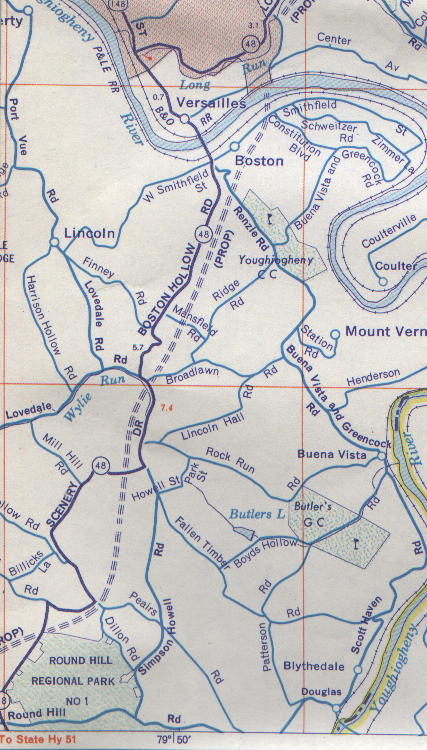
Please Note: This is a general alignment based on the 1968 Gulf Oil Company Map. It is not in specific detail. It shows nothing of the highway in Monroeville...only guess is because Monroeville is gray shaded. The road never touches Westmoreland county but comes very close in places.
Elizabeth Township
The map shows the proposed route as follows. It doesn't show the connection with PA 51 (out of room). However, there is a clearing along PA 51 between PA 48 and Round Hill Rd Extension that suggests that NEW 48 would begin here.
It crosses PA 48 for the first time just South of Elizabeth-Forward High School (probably near the NIKE Site also the then District Offices location) It would have followed the clearing in the valley that separates the houses on top of the hill and Round Hill Park. This would be the valley clearing that shoots out from EFHS Stadium and Bus Depot and sits below Tiganelli Farm. Current PA 48 climbs the hill then heads right along the ridge overlooking the valley. The valley was marked and surveyed well into the 1970s. (5)
It then crosses over Pearis Road (Old PA 884?) During the roughly 1/8 of a mile stretch between PA 48 and Dillon Road. You may recall this as the 90 degree turn on PA 48 where their used to be an old caboose. This would be about 1/2 mile from my house on PA 48. There would have been about 5-6 homes cleared for this crossing. If in fact, they were there at the time.
It would then traverse between Simpson Howell Drive and PA 48 crossing PA 48 near Circle Drive. This would have been not the Mill Hill/ Circle Drive Crossing but the Circle Drive Crossing at the S curve on the hill. PA 48 would have climbed or cleared a hill to that point.
Keep in mind that this area of Elizabeth Township began to develop in-between 1966-1976 so there's another nail in the New 48's coffin. Many of this land was old farmland and is severely undermined.
It would then cross PA 48 at the base of Lovedale Hollow just south of Broadlawn. It would then go along the ridge or through the hill across Mansfield Road (behind the former Puck Jones, now Cross Creek Inn) The route has it between Ridge Rd and PA 48.
It would then cross Renzie Rd before the Sharp Downhill U Curve on Renzie. It would then cross Smithfield St. in Boston near Constitution Ave. How the angle of the road shows , it would bypass many of the older homes along the Boston Slopes. The Yough River Bridge would be a high-level bridge coming from Renzie Hill in Elizabeth Township across the river to near the intersection of Center St. and Center St. Extension in South Versailles.
End Elizabeth Township/Yough River
Yough River North
After PA 48 crosses the Yough, it would shoot straight up to Center Ave., and would be on the downhill slope side of Center Ave. Ext. where it would then turn right to parallel PA 48 on the east side. It would cross Center Ave. Ext. near the natural gas facility and PennDOT Yard. This gives proof to Gene Yao's theory that the current 4 lane 48 was just a better routing of the old twisty curvy PA 48.
From hear on out NEW 48 was proposed on the East side of current PA 48. It crosses Lincoln way at about the Busy Beaver location of Oak Park Mall. giving room for the proposed cloverleaf interchange.
The road hugs PA 48 and White Oak County Park crossing McClintoch basically at the current playground there. It would go into the land of the McKeesport Sportsman Association and would Cross US 30 East of K-mart. It looks like it curves down the east side of the hill that PA 48 currently transverses on. The map ends the proposed highway routing before the current day Conrail tracks.
The following information on PA 48 in Monroeville is courtesy Bruce Cridlebaugh:
The old Monroeville map that the
real estate companies used to give out in the 70s showed a proposed PA
48. It looked like the new highway would've crossed Northern Pike at Deauville
Apartments/LaVale Dr. This would've brought the road to meet US 22 nearly
a mile east of the PA Turnpike -- east of Giant Eagle on Old Wm Penn Hwy
-- in the area of the former Burke's Glen Pool (now a car dealer).
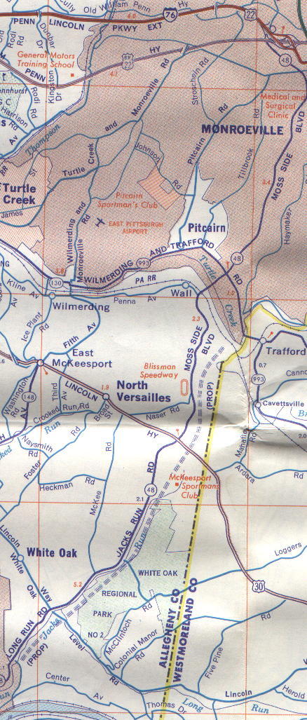
Above: North of Yough
River to Monroeville
Below: South
of Yough River to PA 51
Remnants of Construction:
According to Matt Boyko of White Oak, there are many Right-of-Way acquisition remnants of the New 48. On Center Street in South Versailles and on the east side of current PA 48 are where many of these remnants can be found. Up the decent on Center St. after you turn on if from PA 48 look for a set of steps to your right that lead to no house. A house or two was relocated from here. Proceed along the main road. Now comes another thing to look for. Be on the lookout for the Peoples Gas complex on the left. On the other side of the road are of course about five sets of gas pipeline right of ways. In some of the cleared out areas in and among the pipelines was once a small farm and a house. I believe that this property was acquired by the state. The right of way of New 48 would have ran most likely through here and along the base of the large hill.
Returning onto PA 48 in White Oak
(The 4-laned Section) Now if you glance to the right and behind some of
the businesses, you can tell where the road would have ran. Follow 48 to
the junction of Lincoln Way where the 4 lanes end. Turn right on Lincoln
Way. On the corner is Oak Park Mall which is to your left. This once was
an amusement park, Rainbow Gardens. The state got rid of it. It sat as
a huge vacant area for a long time. The strip mall was built after the
state finally sold off the right of way. To the right directly across
from the strip mall is a large cleared plot of land. No, the state
didn't clear that. It got cleared a couple months ago. However, before
new 48, there was a small neighborhood of 3 streets here. All the homes
had to go. Before the recent clearing, you could tell where a lot of the
homes once were.
Page Created: August 18, 2000
Last Updated: January 6, 2005
(c) 2000-05 William Lawson
If you have any information that
can improve the historical accuracy of this site, please feel free to e-mail
me at aprince4@nc.rr.com.