 |
Carolina Lost:
The
Road to Nowhere
The story behind
the controversial North Shore Road
All photos taken
by Lyndon Young.
|
|
Carolina Lost:
The
Road to Nowhere
The story behind
the controversial North Shore Road
All photos taken
by Lyndon Young.
|
| Unless you
are native to the mountains of Western North Carolina, the incomplete North
Shore Road around Fontana Lake is easily overlooked and forgotten.
But to a number of the descendants of families displaced from the creation
of the Lake, it is a daily reminder of broken promises and years of legal
battles over their former land.
The story of the North Shore Road begins in the early 1940's when Congress appropriated funding for the building of Fontana Dam by the Tennessee Valley Authority (TVA). The damming of the Little Tennessee River created what is now known as Fontana Lake. The 11,685 acre lake would displace over 1300 families in addition to submerging many parts of NC Highway 288, an unpaved road that ran from Bryson City to Deals Gap. (1) In addition, the lake left nearly 44,000 acres of land between it and what was then the boundary of Great Smoky Mountain National Park. With the National Park Service wanting to include the 44,000 acres into GSMNP and the TVA claiming the cost to replace NC 288 as being to high, an agreement between the two government agencies and the State of North Carolina along with Swain County was met in 1943. The agreement would allow the National Park Service to purchase the 44,000 acres at an average cost of $37.76 per acre (1). In addition, the NPS was to build a replacement for NC 288 along the northern shore of the newly created lake. The road would be built as Congress allocated money to the project. In addition, a clause stating “failure on the part of Congress for any reason to make such appropriations shall not constitute a breach or violation of this agreement.” was included. (1) The level of compensation for their land still angers the families and descendants of those displaced to this day. Not long after the 1943 agreement was signed, the first of six decades of lawsuits (from landowners to environmental groups) were filed. Six property owners filed suit to keep their land. Their argument was that because none of their land would become part of the man-made lake; the government did not need their land. After local and district courts sided with the property owners, a 1946 U.S. Supreme Court decision reversed the lower courts' rulings and the government was now legally permitted to seize the land. By that Spring, all of the former families in the area affected by the creation of Fontana lake and the expansion of GSMNP had moved from the area. After the conclusion of the World War II, some money was allocated to the construction of the North Shore Road. A one mile section at Fontana Dam would be built. In 1958, the State of North Carolina builds three miles of the North Shore Road outside of the park's boundary. In 1960, the first construction of the road within the park in over a decade would begin. The 2.3 mile project was near completion when a landslide would expose the environmental and cost concerns in building the highway. Located within a 1962 report of a National Park Service committee that was in charge of inspection of the roadway's construction had this ominous quote "The committee is of the opinion that continuation of such damage to natural park values is indefensible from either the standpoint of conservation or visitor use." (2) While another four miles of the road would be built between 1962 and 1970, the concerns over the roadway's effect on the environment became center issue. Anakeesta rock, which are rocks that when exposed to the elements release a mild sulfuric acid (3), was found during construction of the highway. It was first noticed when snowfall instantly melted on exposed rock and produced a strong sulfur odor. (4) The environmental concerns over the Anakeesta is that the acid that is leaked through rainfall would enter nearby streams and damage plants, fish, and other wildlife. The addition of nearly four miles of the North Shore Road (known within the park as Lake View Road) in 1970 would be the last new portion of highway built to this day. This segment includes a tunnel which is the current end of the highway. Since 1970, the question over whether or not to build the North Shore Road has become an almost annual discussion in Western NC and on Capitol Hill. After years of congressional hearings, failed motions, and other legal battles, the North Shore Road project in 2000 received $16 million in federal funding towards building the highway. The money thus far has been used for studies in determining the eventual final outcome of the project. Over the past two decades, the debate over the North Shore Road concerns three groups - the families and their descendants that want to see the road built, "A promise made is a promise kept.", environmental groups that do not want to see any more of the road built, and Swain County Commissioners that would like to see a cash settlement to improve the finances of the county. For years, politicians from the local, state, and national levels would offer a compromise funding proposal to the residents displaced by Lake Fontana and to Swain County. More often than not, the proposals, like the North Shore Road, go nowhere. Road to Nowhere
Photos:
|
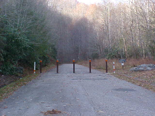 |
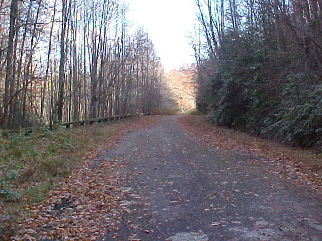
Left Photo: The
furthest you can travel on the North Shore Road. From this point
forward, you can only travel by foot or by bike.
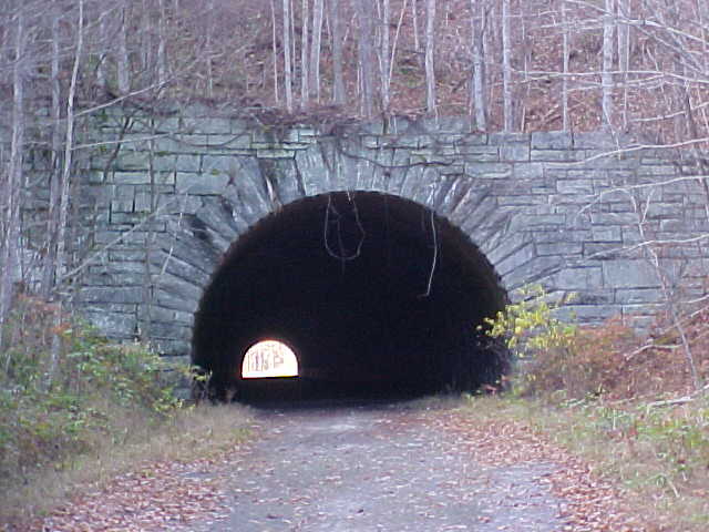
Right Photo: The tunnel is just beyond the barricade. |
 |
 |
Left Photo: Exiting
the tunnel, the road does continue a bit further...
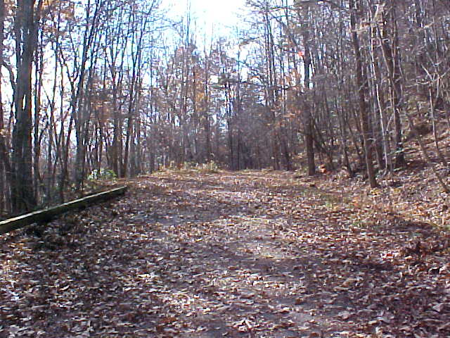
Right Photo: ...until this point. This is the absolute end of the highway that was built in 1970. Fontana Lake is on the left. |
 |
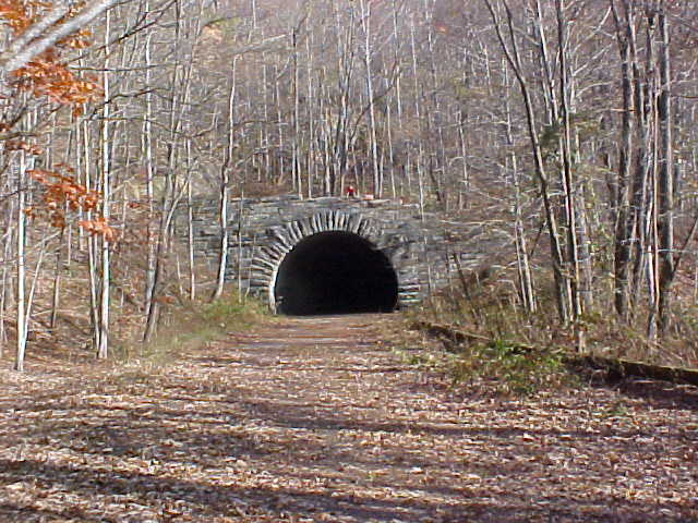 |
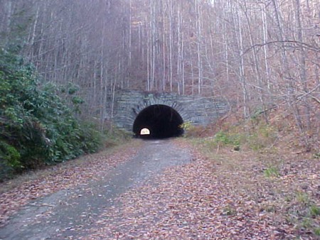
Left Photo: Approaching
the tunnel as you head back to the parking area from the road's end.
Right Photo: Exiting the tunnel and returning to the parking area. |
 |
| Site Navigation:
Sources & Links:
Page Created: October 14, 2007
© 2007 William Lawson |