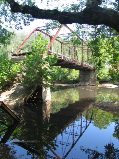
Carolina Lost: Old Hardin Road Bridge over South Fork River - Gaston County
What: Old Hardin Road Truss bridge over South Fork River
Where: Hardins Community - Gaston County
Accessibility: Difficult

Directions:

  • US 321 North from Gastonia to the Hardin Road Exit
  • Turn right at the end of the ramp
  • Follow Hardin Road About One Mile  and bear right. 
  • Old Bridge is about a 1/4 mile hike.

  •  


    *Please Note* - Conditions around the bridge can be very suspect.  It is strongly recommended that a group of two or more should go around to access the area around the bridge.


    Not more than one mile down stream from the old US 321 High Shoals bridge, another old truss bridge over the South Fork River can be found.  However, unlike the High Shoals bridge, the old Hardin Road bridge is in a less desirable condition.  The old truss bridge, which included an elevated approach similar to the US 64 Tar River Bridge, was decommissioned in 1966 (1) when a new bridge carrying Hardin Road was built slightly upstream.

    The old bridge has seen some of the approach spans collapse after years of neglect.  Because of the collapsed spans on the west side of the bridge and a private business on the east shore, it is now impossible to reach the main span over the river.  The remnants of this bridge shows how early truss bridges in North Carolina were constructed, but it also shows the delicate nature of these bridges and how years of neglect can significantly deteriorate these bridges.

    Bridge Photos:
    All photos taken by the webmaster - August 25, 2007.


    Left Image: The elevated approach to the Old Hardin Road Bridge begins.

    Right Image: A dirt path goes underneath one of the elevated sections of Old Hardin Road.

    Left image: The main truss span of the Old Hardin Road Bridge is left standing while an approach span of the bridge has collapsed into the South Fork River.

    Right Image: A closer look at the collapsed bridge span.

    Left Image: A look at how the elevated approach spans to the bridge were built.  Obviously, it doesn't look entirely too safe.

    Right Image: Twisted remains of the old bridge.

    Left Image: Over forty years of vegetation surrounds another collapsed span of the bridge.

    Right Image: A still standing bridge span...but not in the greatest of conditions.


    Site Navigation:
  • Return to Carolina Lost - The Bridges Index
  • Return to Carolina Lost Index

  •  


    Sources & Links:

  • (1) Nationalbridges.com. http://nationalbridges.com/nbi_record.php?StateCode=37&struct=000000000710160 (January 5, 2008)
  • Steven Duckworth

  •  


    Page Created: January 5, 2008
    Last Updated: January 5, 2008

    © 2008 William Lawson