 |
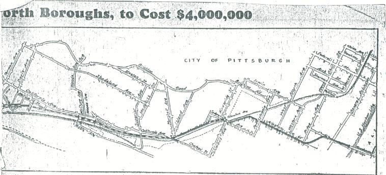 |
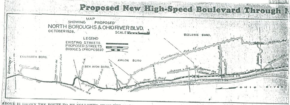
Planning for
Ohio River Boulevard began in the 1920s. (see scans below) Funded by the
1928 County Bond Issue, construction began on the route that would run
from the city neighborhood of Manchester to the Borough of Emsworth. (2)
The four and a half mile brick-paved roadway would be 40 feet wide and
have numerous bridges over local roads and various tributary streams of
the Ohio River. It would end at a grand traffic circle on the North
Shore of the Ohio River at the McKees Rocks Bridge. The route that was
built to relieve traffic and accidents on California Ave. was dedicated
in August 1931 at a final cost of $12 million. (3) Originally maintained
by Allegheny County, the Commonwealth took control of the highway in 1941.
|
|
As traffic levels on Ohio River Blvd. began to increase in the 1950s and 60s, various plans were introduced to improve the highway. Ideas ranged from widening the highway to building a new expressway to current day I-79. Many of these proposals would fall to the wayside because of lack of funding and interest or community protest. During the 1960s, a southern extension of the boulevard to PIttsburgh's North Side was discussed and by 1973 the highway opened from the Ft. Duquesne Bridge to Ridge Avenue and the McKees Rocks Bridge to Beaver Ave. and Chateau St. (5) The missing gap which includes a connection to the West End Bridge did not open until January 1992. (6)
Safety became the number one issue for Ohio River Boulevard during the 1970s. In July 1976, parts of four bridges were closed by the state. Bridges over Jacks Run, Dillsworth Run, Spruce Run and South Freemont St. either had sidewalks closed or both sidewalks and the curb lane shut down. (3) Many of these projects would not begin until the mid 1980s. The traffic circle had earlier been removed as the freeway to the North Shore began to take place. Another rash of fatalities in 1987, including six over a three week period in August of 1987 (7), prompted many local municipalities to heighten traffic patrols, lower speed limits, and drunk driving checkpoints.
Today, Ohio River Blvd. is an eclectic mix of grand homes in Ben Avon to narrow and tight gas stations, restaurants, and repair shops in Bellevue. Many steps have been taken to improve various intersections and facilities along Ohio River Blvd. In 1999, after years of debate and controversy, construction to widen Ohio River Blvd. in Bellevue from Kendall Ave. to the Dillsworth Run Bridge. (8) In 2005, plans to continue the widening south of the Dillsworth Run Bridge to Prospect Street will also become reality.
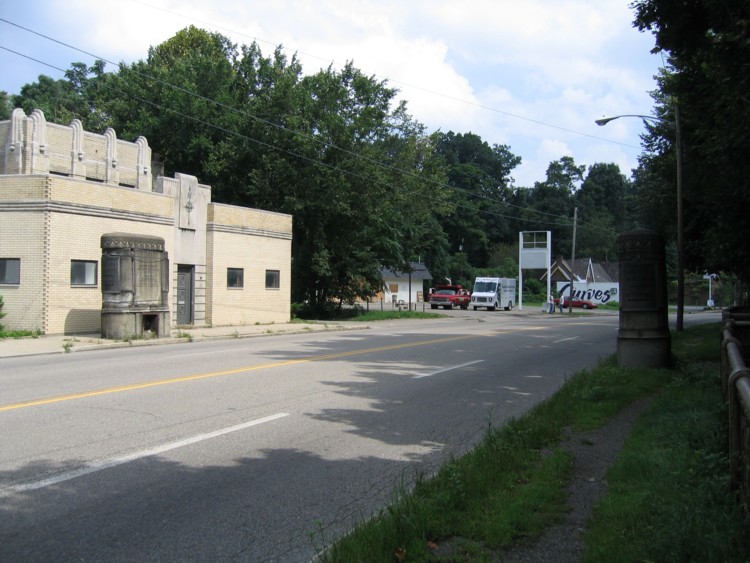
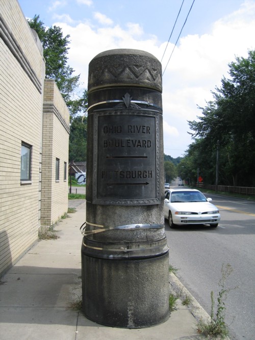
Below, photos
of pylons placed at the beginning of the project near Camp Horne Road in
Emsworth. Despite showing their age, these concrete monuments have
existed for well over seventy years.
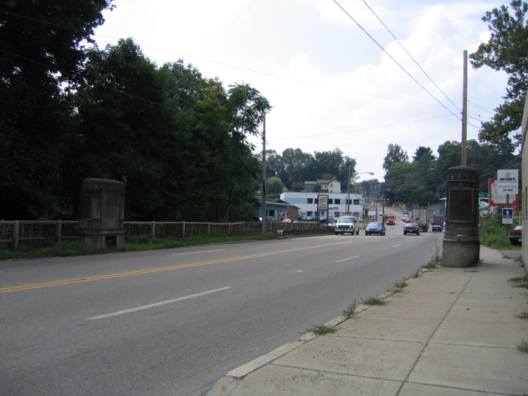 |
Left Image: Looking
outbound at the twin markers at the Emsworth Terminus of Ohio River Blvd.
Both markers read 'Ohio River Boulevard' and 'Beaver' for the Beaver County
Seat further Northwest. (Photo taken by Eric Lasher.)
Right Image: Looking inbound and what was the beginning of Ohio River Blvd. towards Pittsburgh. Sides of these markers read Ohio River Boulevard and 'Pittsburgh'. (Photo taken by Eric Lasher.) |
 |
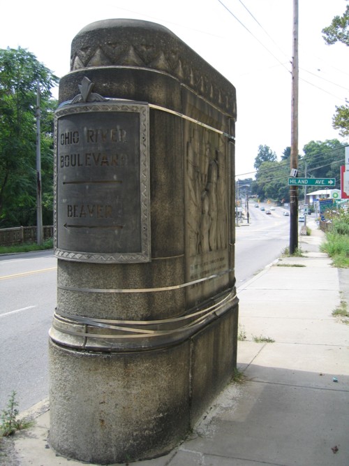 |
Left Image: Close-up
of the outbound facing pylon. The metal bands are placed to hold
the aging, cracking structure together.
Right Image: Close-up of the same marker facing inbound. Time has weathered many of the visual effects of both pylons. |
 |
Page Created: March 3, 2003
Last Updated: August 29, 2004
(C) 2003-04 William Lawson