 |
 |
NC
90 Photo Essay:
The Forgotten Highway of Caldwell County. |
|
|
|
NC
90 Photo Essay:
The Forgotten Highway of Caldwell County. |
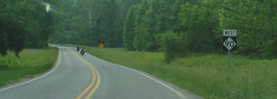 One
of North Carolina's highway secrets is the unpaved portion of NC 90 in
Caldwell County. From a point just beyond the curve, seen in the
photo on the left, to an unmarked location in the tiny community of Edgemont,
highway 90's last few miles are an unpaved journey through country that
is forgotten by many everyday travelers. Although not in as quite
a rugged territory as the mountains of Western North Carolina or some of
the peaks just to the north, the unpaved NC 90 does climb from an elevation
of approximately 1400 feet at the pavement change to close to 2400 feet
in Edgemont. One
of North Carolina's highway secrets is the unpaved portion of NC 90 in
Caldwell County. From a point just beyond the curve, seen in the
photo on the left, to an unmarked location in the tiny community of Edgemont,
highway 90's last few miles are an unpaved journey through country that
is forgotten by many everyday travelers. Although not in as quite
a rugged territory as the mountains of Western North Carolina or some of
the peaks just to the north, the unpaved NC 90 does climb from an elevation
of approximately 1400 feet at the pavement change to close to 2400 feet
in Edgemont.
Although isolated from nearby towns of Lenoir, Blowing Rock, and Boone, this segment does show signs of civilization. Utility poles and a handful of homesteads mark the route. Complete with three one lane bridges, unpaved NC 90 runs entirely through Pisgah National Forest and provides access to campsites within the park's boundary. Below photos from NC 90: |
 Transition
from pavement to gravel. The motorcyclists were forced to turn around. Transition
from pavement to gravel. The motorcyclists were forced to turn around. |
 An
early flat piece of NC 90. An
early flat piece of NC 90. |
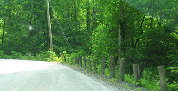 A
primitive guard rail system. A
primitive guard rail system. |
 Lush
green scenery surround this gentle S-curve. Lush
green scenery surround this gentle S-curve. |
 Yes,
there is local traffic on NC 90. Yes,
there is local traffic on NC 90. |
 Tighter
curves are found closer to Edgemont Tighter
curves are found closer to Edgemont |
 This
one lane bridge over Thorps Creek is the longest of the three one lane
bridges. This
one lane bridge over Thorps Creek is the longest of the three one lane
bridges. |
 This
concrete arch bridge is near Edgemont. This
concrete arch bridge is near Edgemont. |
 Rocks,
drop offs, and other hazards make concentration the top priority of motorists
on NC 90. Rocks,
drop offs, and other hazards make concentration the top priority of motorists
on NC 90. |
Site Navigation:Sources & Links:
Page Created: August 1, 2003
(C) 2003 William Lawson |