 |
To The Shore! - North Carolina's Struggle to Build Interstate 40 to the Atlantic Coast. | |
|
To The Shore! - North Carolina's Struggle to Build Interstate 40 to the Atlantic Coast. | |
| One of North
Carolina's most interesting highway stories of the Interstate Era was the
extension of Interstate 40 to the Atlantic Coast. From the
first seeds that were planted in 1963 to the eventual completion of the
highway on June 28, 1990, creating a high-speed Interstate route to the
coast would go from a nearly 20 year oversight to a top statewide priority.
The Interstate 40 saga, however, would place the state's two port cities
-- Morehead City and Wilmington -- into a decade long competition in which
only one city could win. The extension of Interstate 40 would ultimately
be the start of an aggressive road building campaign within the state that
still continues today.
Background:
The state's lack of interest came from focus on other projects including improving the secondary road system. Vance Baise, the state's highway engineer, commented about the state's position on the proposed Interstate System in 1947, "...we certainly do not feel justified in improving any part of the system [with state funds] except as traffic needs require." (1) North Carolina would originally be allotted 714 miles of Interstate in 1956 (I-26, 40, 85, and 95) and would gain another 62 miles a year later with the creation of I-77. (1) By 1959, five sections of North Carolina's Interstate Highway System were open to traffic (2). By 1963, many pieces of I-40, 85 and 95 were open, under construction or being planned. History:
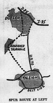
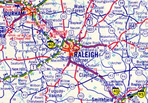
In 1963, North Carolina made one of their first attempts to extend the Interstate System within the state. The state petitioned for two extensions: One, a route from Durham via Raleigh to Morehead City, and the second, a route from Charlotte to Wilmington. (1) It appears that the Durham-Raleigh-Morehead City route evolved from another and possibly earlier -- maybe as early as 1959 -- Interstate request to connect Raleigh to Interstate 85. (See image at right) The proposal actually consisted of three spur routes: 1) From I-85 through Central Durham to Research Triangle Park (RTP) This spur was of two segments, the Durham East-West Freeway and the Research Triangle Park North-South Freeway 2) RTP to the Raleigh Beltline and 3) A route connecting "Spur 1" to Interstate 85 along the eastern edge of Durham. (3) What is interesting is that although the three spur routes were not approved, two of the three ("Spur 1" is the predecessor of the NC 147 Durham Freeway, "Spur 2" is actually I-40 eastwards from NC 147 and Wade Ave. Extension) were eventually built, and "Spur 3" became the much embattled and still un-built "East End Connector". Both of the proposed 1963 extensions did not gain approval and were shelved. However, the dust on either idea would not settle for long. By 1968, Interstate 40 would have two new sections of highway open to traffic. Both were in the western part of the state, one on the south side of Asheville, the other a bypass of Canton. At the same time construction was underway to connect Statesville to Winston-Salem, around Asheville and from Cove Creek north to the Tennessee line. It was also in 1968 when the state would again petition for additional Interstate mileage, and this time they would be successful. That December, the state would be granted two Interstate extensions. The first was nine miles of Interstate 77 from Charlotte to the South Carolina State Line. This was part of I-77's overall extension to Columbia, SC. The second was a 49 mile Interstate extension from Durham to I-95 in Smithfield via Raleigh. (1) This would become part of an I-40 extension, and throughout the early to mid-1970s this route was shown on numerous maps. (See Below)
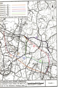
With the 1968 extensions in place, the state was very aggressive in making Interstate requests in 1970. The state would request routes for eleven new corridors totaling an estimated 673.9 miles. (4) Three of the requests would involve Morehead City and Wilmington. Two of the three corridor requests ended in Wilmington. The most lengthy was a 245.4 mile corridor from Asheville to Wilmington via Charlotte. This route would basically follow US 74. The second Wilmington corridor request ran 159 miles southeast from Greensboro. This proposal essentially followed modern US 421. The Morehead City route branched from the Greensboro to Wilmington route around Clinton and ran 85 miles east. This corridor followed mostly NC 24. But like 1963 all eleven were denied; however, some and parts of these requests would evolve and resurface as other approved corridors that are now either open or under construction Interstate Highways today. After the 1970 refusals, talk turned to extending I-40 beyond Interstate 95 eastwards to the Atlantic Coast. In various transportation forums, it is believed that early proposals were to extend I-40 to Morehead City via the US 70 corridor. This would include the US 70 freeway from Dover (east of Kinston) to New Bern in Craven County which opened around 1980. This seems to be confirmed in that during the first term of Governor Jim Hunt's administration (1977-81) the Governor led the way to moving and also extending I-40 in a more southeastern direction to Wilmington. (1) Also during the 1970's, North Carolina continued to work on the completion of the legacy I-40 corridor while working on the 1968 extension. Early in the decade, Statesville and Winston-Salem would be connected. In 1976, a missing 14 mile section in Hickory opened. The final area of I-40 would be the Old Fort and Swannanoa corridor. First, the 1950s era US 70 climb of Black Mountain and Point Lookout was upgraded to Interstate standards in 1974. The final piece of the original I-40 was placed in 1979 when a segment from Black Mountain to Swannanoa was opened. At the same time, work began and was completed on the first segments of the 1968 extension, oddly the I-40 extention would also include the general routing of "Spur 2" of the 1959 proposals. Interstate 40 would be built and open by 1973 from RTP to the Raleigh Beltline. Building Interstate 40 from I-85 to RTP would take more time to complete. When the state made their 1968 proposal for the extension, the request was to route Interstate 40 over I-85 to NC 147 - then called the Durham East-West Freeway and the Research Triangle Park North-South Freeway - then along current I-40 towards Raleigh. In May 1969, not long after the December approval, the FHWA suggested to NCDOT that changes would be needed to the East-West Freeway in Durham. (5) The suggestion was to eliminate some ramps or interchanges and to add additional lanes to handle city and Interstate traffic. As a result, NCDOT decided to do an entire corridor study. The study was released in August of 1970 with five additional possible corridors for the extended Interstate 40. The six alternatives were:
In January 1971, NCDOT selected Alternative 1 as their preferred corridor. (6) In August 1973, a Draft Environmental Impact Statement was released. Alternative 1 is not the same route that I-40 follows from I-85 to NC 147 today. The 1970 route is further to the north and east than current I-40. It is not known when and what caused the changes to Interstate 40's eventual alignment. Two speculative concerns are the alternative's proximity to Duke Forest and historical structures along Old NC 10 in University. The first segment of I-40 from I-85 to RTP opened in 1985 and the entire corridor was completed by the fall of 1988. Meanwhile, the state's Transportation Board's made a decision to extend Interstate 40 to Wilmington in April of 1978 (7). As a result, the entire decade of the 1980s were devoted to completing the remainder of the Interstate to Wilmington. By 1984, right-of-way purchases from Raleigh to Wilmington were essentially complete. (1) And by 1985 construction was underway along almost the entire corridor. During the Governor James G. Martin administration (1985-1992) administration, the dominoes to a completed I-40 would fall. Beginning with the completion of the southern half of the Raleigh Beltline in 1985 to the uncovering of a "Barstow, Calif 2,554" sign in Wilmington on June 28, 1990 (1), an Interstate highway to the coast would finally become a reality. Impact:
The priority of completing I-40 was not without its drawbacks. Some very needed improvements to I-40 itself were delayed because of funding shifts in the Wilmington push. Two of which were the widening of I-40/85 from Greensboro to Hillsborough (constructed and completed in the 1990s) and the construction and completion of a new southern route of I-40 around Winston-Salem in 1993. (1) The change of planning for all related I-40 projects would not have been possible without the creation of the state's Transportation Improvement Program (TIP). The TIP was a seven year long range planning tool first published in October 1973. (1) The creation of this program would greatly focus the state on future road priorities and in the 1980s, Interstate 40 certainly benefited from it. Near the end of I-40's construction, the State Assembly tackled the persistent problem of inadequate funding of the DOT. In 1989, they passed legislation that created the Highway Trust Fund. The trust fund, which was created to push an even more aggressive highway construction approach that was evident throughout the 1990s and beyond 2000, was created to advance the construction and upgrade of highways throughout the state, specifically creating an "Intrastate Highway System" designed to put 90% of the state's population within ten miles of a four-lane highway and of an urban loop and connector system of several of the state's major cities. (1) The story of Interstate 40 and the push of an Interstate route to the North Carolina Coast travels nearly sixty years. The need for this highway would help to shape a drastic change in the state's approach to and outlook of its highway system. When it was completed in 1990, Interstate 40 helped to revolutionize and modernize North Carolina's highways. Any additional information
about the history of the I-40 expansion of the Morehead City proposals
should be addressed to the webmaster.
Site Navigation & Links:
© 2006 William Lawson |