|
|
|
|
 |
Trunk
Route 1: Appalachian
Highway. This route was marked with a red and white band with the
letter 'A' superimposed. Part of this route (North Carolina State
Line southwards to Newberry) would become the original routing of US 176.
Many pieces of US 176 in the Upstate were once part of the Appalachian
Highway.
The Route Today:
Get
your maps out! The Appalachian Highway would generally follow US
78 out of Charleston to US 178 near Dorchester. It then follows US
178 to US 601 in Orangeburg. US 601 to SC 6 in St. Matthews.
SC 6 to US 176. US 176 to US 76 near Irmo. US 76 to SC 121
in Newberry. SC 121 to US 176 south of Whitmere. US 176 to
SC 215 in Union. SC 215 to SC 56 in Pauline. SC 56 to its end
at US 176 (again) outside of Spartanburg. US 176 to the North Carolina
State Line. Please Note: This is a general route listing.
As new information is presented, it will be updated.
|
|
 |
Trunk Route 2:
Old State Road. This route was marked with a blue and white band
with the letter 'S'. This appears to have roots to the early 19th
Century. The route appears to have begun in Charleston, worked
its way towards Columbia, and then to Greenville. It is unclear if
the Old State Road went into North Carolina via Travelers Rest (US 25 today).
Or as a 1926 State Highway Department shows SC 2, it headed west towards
Clemson and Seneca before turning north through Mountain Home and into
Georgia.
Modern Clues: The road was also mentioned in a 1927 description of Berkely County. East of of Charleston the Old State Road seems to have followed modern US 52/78. In Goose Creek, specifically near the Eastern terminus of US 176 there is a posted 'Old State Road' between Redbank and NAD Roads. Further east, there are also 'Old State Road' listings in the Cooper-Santee Lake area specifically along US 176 in Holly Hill, Cameron and St. Matthews. In Cayce, the furthest known listed 'Old State Road' runs parallel to the east of SC 35 (see map at right). A stone bridge, The Poinsett Bridge, in Greenville County dates to 1820 and was part of the Greenville to Columbia to Charleston Route. (1) It appears the between 1920 and 1926, part of the Old State Road between St. Matthews and Goose Creek was designated SC 31. Route 2 would run along the Appalachian Highway -- former Trunk Route 1 -- slightly south and parallel to SC 31. Today, US 176 follows what was once the Old State Road between the two towns. |
|
 |
Trunk
Route 3: New York-Florida Highway. This route was marked
with a red, white and blue band with the letter 'W'.
Modern Clues:
In 1926, SC Route 3 was a precursor to US 76's route from North Carolina
to Columbia. SC 3 entered the state near Mullins and continued west
through Marion, Florence, and Sumter before ending at Columbia. From
Florence to the NC Line, SC 3 was part of former Trunk Route 6 - The Coast
Highway. It is possible that the New York-Florida Highway shared
an alignment with the Coast Highway through part of its journey within
South Carolina.
|
|
 |
Trunk
Route 4: Piedmont Highway. This route was marked with
a green and white band and the letter 'P'. Current day SC 20 is known
as the Piedmont Highway from the city of Greenville to the town of Piedmont.
The Piedmont Highway is shown in Laurens County in the 1927 Clason's Auto
Trails Map. However, there is also a "Piedmont Air Line" shown on
the same map in Greenville County and then crossed into North Carolina.
(2)
Modern Clues: In 1926, SC 4 ran from Effingham to Orangeburg via Manning along basically what is US 301 today. From Orangeburg, SC 4 ran west, over much of what remains SC 4 today, to SC 27 north of Windsor. Like Trunk Route 3, it is not clear if the 1926 SC 4 was the same routing as Trunk Route 4/Piedmont Highway. |
|
 |
Trunk
Route 5: Carolina Highway. This route was marked with
a red, white and orange band and the letter 'C'.
Modern Clues: The 1926 version of SC 5 shows it running from Blacksburg to York via Smyrna and Hickory Grove, east to Rock Hill, then turning south to end at SC 9 at Fort Lawn. It is not known at this time if this was in fact the Carolina Highway. |
|
 |
Trunk Route 6:
Coast Highway. This route was marked by a black, white and orange
band and the letter 'G'. This route was the predecessor to the Atlantic
Coastal Highway and later the original routing of US 17.
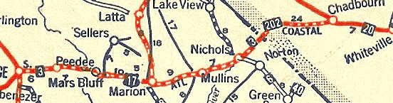
Routing: The Coast Highway entered South Carolina from Savannah, GA to Walterboro to Charleston to Florence to Marion east into North Carolina. By 1926, Trunk Route 6 would be broken up into a number of state routes. The Coast Highway would become SC 1 from Georgia to Yemassee, SC 30 from Yemassee to Walterboro, SC 6 from Walterboro to Charleston, SC 2 from Charleston to Goose Creek area. SC 41 from Goose Creek to Florence (see map at right), and finally SC 3 from Florence to North Carolina (see map below).
The Route Today:
If
you wish to trace the route of the Coast/Atlantic Coastal Highway today,
here is the modern day routing of the former Trunk Route 6: SC 170 to US
17 to US 17 ALT to SC 64 to US 17 to S-10-40 to SC 174 to SC 162 to US
17 to US 52 to US 76. Please Note: This is a general route listing.
As new information is presented, it will be updated.
|
 |
 |
Trunk
Route 7: Pee Dee Highway. This route was marked by a green,
white and orange band and the letters 'P.D.' A section of highway
named the 'Pee Dee Highway' runs parallel to the Little Pee Dee River between
US 501 in Anyor and US 701 in Horry County. Also, an 'Old Pee Dee
Highway' exists north of Anyor in Galivants Ferry.
Modern Clues: By 1926, Trunk Route 7 had been replaced by most likely SC 38 in the Pee Dee Region. It is not known what the exact routing of the Pee Dee Highway was. In 1926, SC 7 bisected South Carolina running from the Georgia Line west of Abbeville, then to Greenwood, northeast to Clinton, across to Chester, then north through Rock Hill and Fort Mill before entering into North Carolina south of Charlotte. |
|
 |
Trunk
Route 8: Trans-Montane Highway. This route was marked
by a black, white and red band and the letter 'M'.
Modern Clues: In 1926, SC 8 follows what would become today's US 29. Although, US 29 through the upstate does not traverse overly mountainous territory, it is possible that Trunk Route 8 and SC 8 are the same highway. |
|
 |
Trunk Route 9:
National Highway. This route was marked by a red, white and blue
band and the letter 'N'. The 1922-23 Rand McNally Auto Trails Map
lists the National Highway, but the marker is red, white, and blue minus
the letter 'N'. The National Highway was the predecessor to today's
US 1. However, a 1927 Clason's Auto Trail map shows the National
Highway through Anderson following modern-day US 29 and towards Greenville
on modern SC 81. (see map at right). It has also been listed
as the Atlantic Highway.
Trunk Route 9 would be short-lived as SC 9 in 1926 follows most of its modern alignment. Routing: Entered South Carolina at North Augusta through Columbia and into North Carolina above Cheraw. (2) |
 |
| Editors Note: (*) At this time there is no available information on the layout of the Trunk Route markers, the design of the markers are based on the designer's interpretation of the descriptions listed in the AAA 1920 Highway Greenbook. | ||
 Routing:
The route ran a somewhat zig-zagging trek from the ocean to the state line.
Generally, the Appalachian Highway ran from Charleston to Orangeburg to
Columbia (via St. Matthews) to Newberry to Union to Spartanburg (see map
at right) to finally entering North Carolina north of Landrum. By
1926, Trunk Route 1 would be assigned SC 19 from the State Line to Newberry
and SC 2 from Newberry to Charleston. These two designations are
a lot easier than what routes former Trunk Route 1 follows today.
Routing:
The route ran a somewhat zig-zagging trek from the ocean to the state line.
Generally, the Appalachian Highway ran from Charleston to Orangeburg to
Columbia (via St. Matthews) to Newberry to Union to Spartanburg (see map
at right) to finally entering North Carolina north of Landrum. By
1926, Trunk Route 1 would be assigned SC 19 from the State Line to Newberry
and SC 2 from Newberry to Charleston. These two designations are
a lot easier than what routes former Trunk Route 1 follows today.