
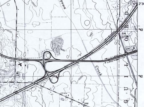
This is one of the more unusual of the truly rural interstate to interstate highway connections. US 224 was originally built through here on its current routing in the 1950s as a well engineered two lane highway. I-71 followed by the early 1960s and the 4 laning of US 224 to the east and its addition to the I-system was in place by the mid 1960s. To the west, US 224 continues as an 'almost freeway' 4 lane divided 'expressway' (completed by the early 1970s) for about 15 km bypassing Lodi, OH with the expressway ending at the western intersection of US 42 and US 224. Both highways then continue as lowly two lane roads.
I-71 is a VERY well engineered interstate highway, built similarly to the Ohio Turnpike, with relatively few interchanges. The next interchange to the northeast is about 14 km away, the next to the southwest is about 10 km away. (Just add a tollgate...)
The interchange itself is a tricky connection where the two highways meet in a valley at the bottom of a 50-100 meter high ridge (to the west). The connector roadway is undivided with less than 100 meters between the ramps and has been the site of numerous collisions over the years.
I am unsure as to why this curious 'double trumpet' was built, as there is plenty of clear land in the vacinity for something more 'direct'.
* I-76 was originally marked as 'I-80S' when it was first placed on the I-system.
*The village of 'Westfield Center' (just off the map to the west) was renamed from 'Leroy' in the 1970s.
 |
|
 |
 |

|
Just follow this sign to make your OWN great signs!!!! |
|
|
This page © Michael G. Koerner |
|
|---|