
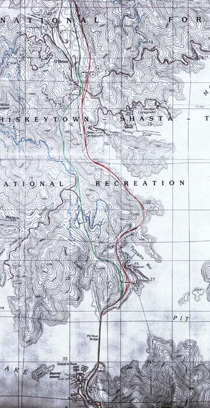
I-5 runs north-south through here, I have colored the northbound side red and the southbound side green. Mixed in is Union Pacific's intensely busy ex Southern Pacific north-south west coast mainline. Scale is 1 km per regular grid 'square', elevation contour interval is 40 feet (about 12 meters).
I-5 in northern California and southern Oregon is one of the most scenic drives ANYWHERE, and where it passes through the 'Whiskeytown-Shasta-Trinity National Recreation Area' and over Lake Shasta just north of Redding, CA is probably the most scenic and interesting part of all.
US 99 and the railroad both origionally followed the Sacramento River through this area (just west off this map) until the Shasta Dam was completed, creating Lake Shasta and obliterating both grades. US 99 was rerouted to a new course and the railroad was relocated to a WELL engineered, new high-speed grade with oodles of tunnels (there are 6 of them on this map alone) and interesting bridges (the parts of the railroad still along the river have MUCH heavier curvature and a slower speed limit). Later on, I-5 was constructed and US 99 decommissioned, with the former US 99 roadway appearing to become the southbound side of the new interstate (I could be wrong here). This was the LAST section of I-5 in California to become fully interstate compatible.
The bridge over Lake Shasta is an interesting two level structure, with the railroad running under the highway. The railroad enters a tunnel right at the south end of the bridge, directly under the freeway.
Much of the territory on this map appears to be privately owned as there are many houses, most served by gated private access roadways (I have colored these roads light blue). Roads that appear to be public are highlighted in black. ALL of the development on this map, including the public boat ramps and park areas, is accessable only via I-5. There are also a small handfull of minor sideroads eminating from I-5 itself, these are used by Union Pacific to maintain the railroad.
There is a STRIKING difference in elevation between the two sides of I-5 through here. Southbound crests at about 500 or so meters while northbound averages about 375 meters. This elevation difference causes this section of I-5 to include an 'over-under' crossing, located at the interchange just north of the bridge (SB over/NB under). The roadways of I-5 'switch sides' in elevation north of the 'O'Brien' interchange, with northbound running as much as 30 meters higher than southbound.
A FASCINATING drive that should not be missed!
 |
|
 |
 |

|
Just follow this sign to make your OWN great signs!!!! |
|
|
This page © Michael G. Koerner |
|
|---|